Features
Features your CKAN water data hub includes when enabling the Geoconnex integration.
If your CKAN instance stores CKAN datasets or custom geospatial features about real-world hydrologic features with ckanext-gztr, you can opt-in to retrieve and share data with the Geoconnex water data knowledge graph.
By enabling the Geoconnex integration for your CKAN instance, your instance will be provided dataset discovery in Geoconnex among participating Geoconnex-enabled CKAN instances.
Explore the multiple benefits that this synchronization has to offer here, and on the next page we'll cover how to enable Geoconnex capabilities for your CKAN instance.
Mint Persistent Identifiers (PIDs) for your CKAN instance's data
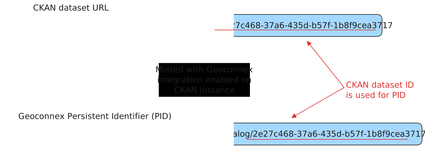
By enabling the Geoconnex integration, your compatible CKAN datasets should be minted a Geoconnex persistent identifier (PID) as a new URL to link to your CKAN dataset's landing page. We use the CKAN dataset id value from the /api/3/action/package_show endpoint as the PID unique ID value, along with a namespace you'll define when enabling the Geoconnex integration such as New_Mexico_Water_Data_Catalog.
For example review the following diagram then the bullet point list afterwards as they relate to the CKAN-Geoconnex integration:
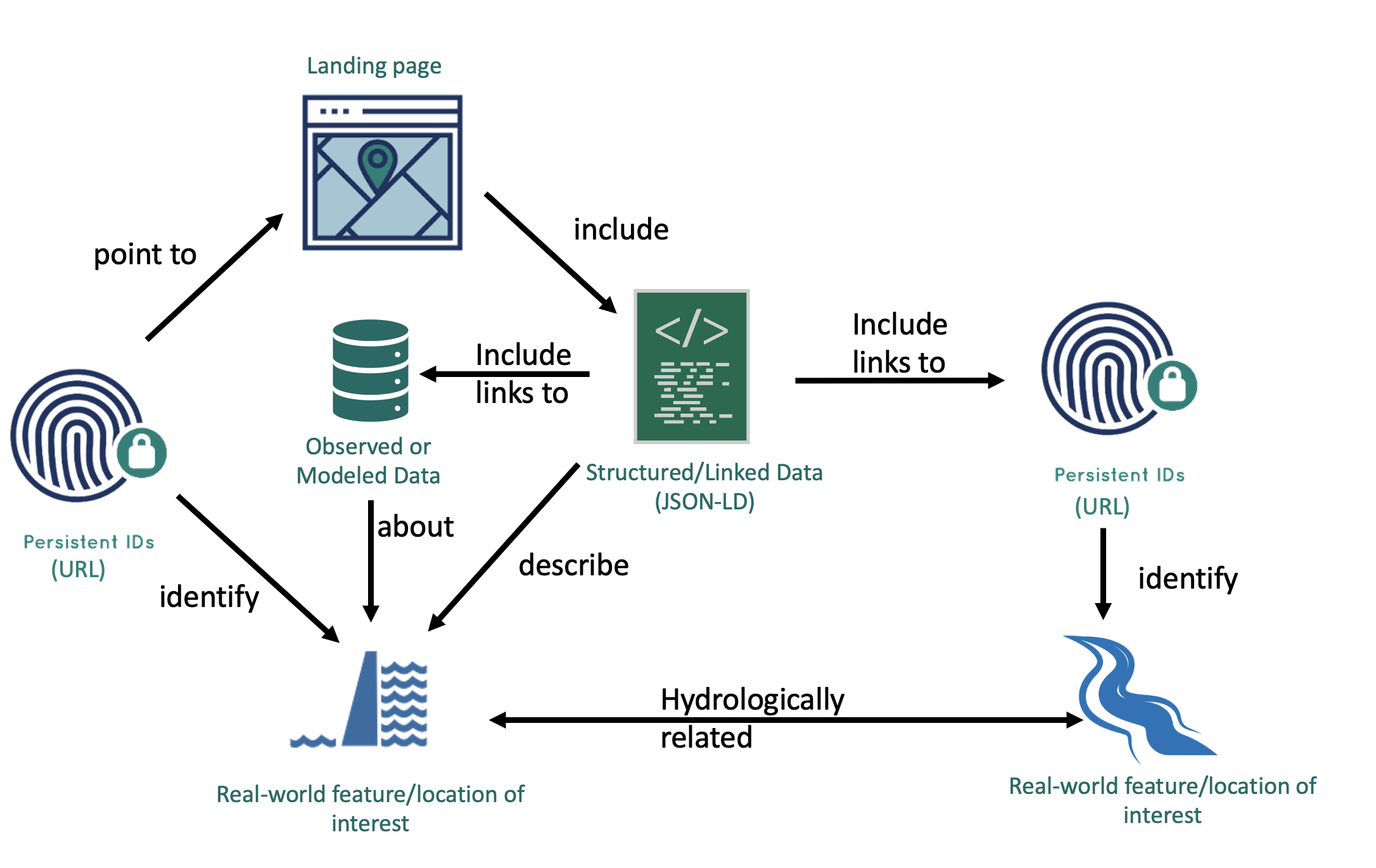
- Persistent IDs (URL) (on the left side): your CKAN dataset's minted PID (e.g.
https://geoconnex.us/ckan/New_Mexico_Water_Data_Catalog/2e27c468-37a6-435d-b57f-1b8f9cea3717) - Observed or Modeled Data: a CKAN dataset
- Landing page: a CKAN dataset's landing page (e.g. https://catalog.newmexicowaterdata.org/dataset/2e27c468-37a6-435d-b57f-1b8f9cea3717)
- Structured/Linked Data (JSON-LD): JSON-LD that describes the CKAN dataset and includes reference PIDs that the CKAN dataset is about
- Persistent IDs (URL) (on the right side): Geoconnex reference feature PID(s) based on geospatial features you've selected in the dataset publisher gazetteer (e.g. Santa Fe, so the PID is https://geoconnex.us/ref/places/3570500)
Associate real-world features/locations with your CKAN datasets
As mentioned in the previous section, there are real-world geospatial features/locations that you can associate with your CKAN datasets. This association is achieved through the dataset publisher gazetteer.
You may review the Geoconnex reference collections lab to learn how to import water data geospatial collections from the Geoconnex reference API to access the data from the dataset publisher gazetteer while also ensuring the imported data is compatible with the Geoconnex integration.
Expose Geoconnex-compatible JSON-LD linked data on CKAN dataset landing pages
With the Geoconnex integration enabled along with the relevant configuration values:
# == ckanext-gztr | Geoconnex options (more info at https://gztr.dathere.com/docs/geoconnex-integration) ==
ckanext.gztr.geoconnex.enabled = true
# The namespace that should exist in the namespaces/bulk/ckan directory at https://github.com/internetofwater/geoconnex.us
ckanext.gztr.geoconnex.namespace = New_Mexico_Water_Data_Catalog
# Embeds Geoconnex-compatible JSON-LD within each compatible CKAN dataset's landing page
ckanext.gztr.geoconnex.enable_dataset_jsonld = true
Your compatible CKAN datasets should include JSON-LD embedded in each landing page's HTML. For example the JSON-LD may look similar to the following:
{
  "@context": {
    "@vocab": "https://schema.org/",
    "gsp": "http://www.opengis.net/ont/geosparql#"
  },
  "@id": "https://geoconnex.us/ckan/New_Mexico_Water_Data_Catalog/2e27c468-37a6-435d-b57f-1b8f9cea3717",
  "@type": "Dataset",
  "about": [
    {
      "@id": "https://geoconnex.us/ref/places/3570500"
    }
  ],
  "name": "Northwest Well and City Wellfield Water Level Monitoring Program",
  "provider": {
    "@type": "Organization",
    "name": "City of Santa Fe"
  },
  "url": "https://catalog.newmexicowaterdata.org/dataset/2e27c468-37a6-435d-b57f-1b8f9cea3717"
}
Explore the Geoconnex web UI for your geospatial features
When your geospatial collections have geoconnex_pid in a feature's properties value, the Geoconnex URI can be accessed from a geospatial feature's information modal by clicking the information modal button.
Sync your geospatial collections with Geoconnex reference features
TODO: Description explaining how Geoconnex sysadmins can automate retrieving up-to-date data similar to how it was described in the lab but with an orchestration tool. Also actual implementation of examples.




Find your CKAN instance's data linked on the Geoconnex Explorer
TODO: Identify if this is currently possible, to display dataset-oriented web resources on the Geoconnex explorer. If so, then CGS imports a CKAN instance's data-oriented web resources into Geoconnex. Then we identify the data on the explorer.
Query for your CKAN instance's data with SPARQL against the Geoconnex knowledge graph
TODO: Identify if this is currently possible, to retrieve dataset-oriented web resources from a SPARQL query. If so, design a SPARQL query that would fulfill this expectation. Then CGS imports a CKAN instance's data-oriented web resources into Geoconnex. Then we run the SPARQL query and add a test(s) to the testing suite to verify the SPARQL query works.
Run a SPARQL query with the SPARQL Helper
TODO: Complete previous TODO then demonstrate with a GIF/MP4 and example query/link that a public user can copy and run.
Run a SPARQL query using Python
TODO: Complete previous TODO then demonstrate with a GIF/MP4 and example query code that a public user can copy and run.